RussiansInUSA editorial team · Facts checked November 11, 2026
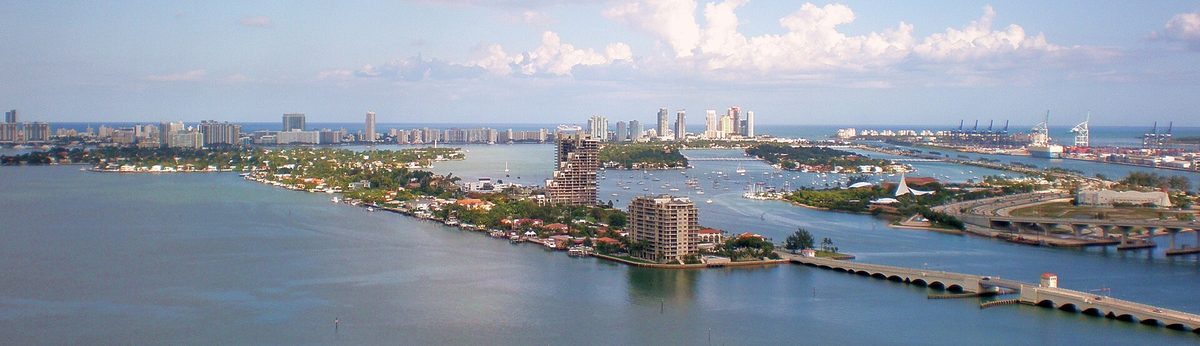
The Venetian Islands in Miami are a chain of six islands in Biscayne Bay strung along the Venetian Causeway, which runs about two and a half miles and over twelve bridges from NE 15th Street near downtown Miami to Dade Boulevard in Miami Beach. The islands are almost entirely residential. People come for the road itself: low bridges with pierced concrete railings, water on both sides and views of the Miami and Miami Beach skylines. Its National Register nomination calls it the oldest causeway in the county.
History of the Venetian Islands and the causeway
Before the islands there was the Collins Bridge, a wooden bridge finished in 1913 by Miami Beach pioneer John S. Collins. The National Register nomination says it was thought at the time to be the longest wooden bridge in the world.
In 1916 F.C.B. Le Gro dredged a small island in the bay and named it Belle Isle, developing it together with Collins. In 1921 Hugh Anderson and Josiah F. Chaille formed the Bay Biscayne Improvement Company, with Le Gro as vice-president and Miami Herald publisher Frank B. Shutts among the directors. Their plan was to pump up new islands from the bay bottom alongside the Collins Bridge and sell house lots on them.
The name was deliberate: buyers were meant to think of Venice, villas of Italian inspiration among water and small islands. The islands were platted under Italian names: Rivo Alto in February 1922, Di Lido in January 1923, San Marino and San Marco in June 1923. Together they held over 450 lots. This was the Florida land boom, and lots were sold from the plats while still underwater. Contracts promised a seawall, roads and utilities, a new road to replace the old bridge, and no toll on it for island residents.
Work on the concrete causeway began in February 1925. Engineer Harvey Stanley drew the plans, the Raymond Concrete Pile Company of New York built it, and the cost was estimated at $2 million. An embargo on shipping building materials pushed completion past the end of 1925, and the nomination records a formal dedication on February 28, 1926. The county's bridge replacement page says the causeway was constructed in 1927. Planks from the old Collins Bridge are still embedded under the road on the landfill sections.
Biscayne Island, the westernmost, was not part of the original project; it was platted in December 1936.
The causeway is listed on the National Register of Historic Places (reference 89000852), and the cities of Miami and Miami Beach have designated its bridges historic landmarks. Miami-Dade County's transportation department (DTPW) runs it today. The county says the bridges are moderately to severely deteriorated after many repairs and plans to replace 11 of the 12, with new bridges 16 feet wider and higher above the water for sea level rise. Status is on the county's project page.
What to see on the Venetian Islands
From west to east the islands are Biscayne Island, San Marco, San Marino, Di Lido, Rivo Alto and Belle Isle. The City of Miami Beach runs a road restoration project on San Marino, Di Lido and Rivo Alto.
The Miami entrance. At NE 15th Street stand two tapering octagonal concrete towers topped by lights shaped like small lighthouses. The north tower is inscribed "Short Way" and the south one "Venetian Way".
The bridges and railings. Bridge 1, from the Miami shore to Biscayne Island, is the longest at about 0.4 mile, with a steel drawbridge in the middle. Between San Marco, San Marino, Di Lido and Rivo Alto each gap is crossed by two short bridges resting on a narrow landscaped strip of fill. The second drawbridge sits between Rivo Alto and Belle Isle. Look at the concrete guardrails: square units with diagonals forming an "X" pattern, open enough to see the bay from every bridge.
The houses. The 1989 nomination describes houses ranging from 1920s Mediterranean Revival to contemporary ranch style, with high-rises at both ends on Biscayne Island and Belle Isle. The houses are private homes, not a park or a museum, so look at them from the causeway itself.
Belle Isle Park. This Miami Beach city park is open daily from sunrise to sunset. It has a shaded playground for ages 2 to 5 and 5 to 12, picnic tables and benches, and a bark park with two dog runs, a drinking fountain with a pet bowl and a walking path. Parking around the park is metered.
How to get to the Venetian Islands
By car. The causeway starts at NE 15th Street in Miami and ends at Dade Boulevard in Miami Beach. It is a toll road and cash is not accepted. Weight limits apply, and vehicles may be at most 10 feet wide including the load.
By bus. Metrobus route 15 runs from the Omni Bus Terminal (NE 15th Street and Biscayne Boulevard) to Dade Boulevard and 23rd Street in Miami Beach. Its route map shows it on Venetian Way across the islands, and its timetable has buses about every half hour in the daytime. The fare is $2.25, or $1.10 discounted. Schedules are on the county's Metrobus page.
By free trolley. The Miami Beach South Beach trolley has a stop on Venetian Way at East Island Avenue. The city calls its trolley free; it runs daily from 8 am to 11 pm about every 20 minutes.
Tolls, hours and tickets
There are no tickets for the islands. Only driving across is paid, at a four-lane toll plaza handling traffic both ways, by SunPass or by Toll-by-Plate (a bill sent to the plate owner), which costs double.
| What | When | Cost |
|---|---|---|
| Car, 2 axles | Per trip | $3.25 SunPass, $6.50 Toll-by-Plate |
| 3 axles | Per trip | $6.50 / $13 |
| 4 axles | Per trip | $9.75 / $19.50 |
| 5 axles | Per trip | $13 / $26 |
| Property Owner Plan (Venetian Islands owners) | October 1 to September 30 | $0 |
| Commuter Plan (island and Sunset Harbour residents, and island workers) | October 1 to September 30 | $120 per vehicle |
| Belle Isle Park | Daily, sunrise to sunset | Metered parking |
| South Beach trolley | Daily, 8 am to 11 pm | Free |
Hours and prices checked November 11, 2026 on miamidade.gov and miamibeachfl.gov. The toll rates took effect October 1, 2025. Annual plans are for two-axle non-commercial vehicles with an active SunPass, take up to 7 business days to process, and questions go to 305-854-2468.
Tips before you go
Without a SunPass you pay twice as much: $6.50 instead of $3.25 for a car.
Pedestrians and cyclists use the causeway, but the county itself says the current bridges are narrow for cars, people on foot and bikes.
With children or a dog, stop at Belle Isle Park for the playground, picnic tables and dog runs. More places are on our what to see in Miami list, and the city itself on our Miami page.
Questions people ask
How much is the Venetian Causeway toll?
A regular two-axle car pays $3.25 with SunPass or $6.50 with Toll-by-Plate, a bill mailed to the plate owner. Cash is not accepted at the toll plaza. Venetian Islands property owners cross free on an annual plan, and residents and island workers can buy a Commuter Plan for $120 a year.
Can you walk around the Venetian Islands?
Pedestrians and cyclists do use the Venetian Causeway, though the county calls its bridges narrow. The homes on the islands are private property, so stay off it and look from the causeway. The public spot to stop is Belle Isle Park in Miami Beach, open daily sunrise to sunset, with a playground and dog runs.
How do I get to the Venetian Islands without a car?
Metrobus route 15 runs from the Omni Bus Terminal at NE 15th Street to Dade Boulevard in Miami Beach along Venetian Way, for a $2.25 fare. The free Miami Beach South Beach trolley stops at Venetian Way and East Island Avenue, daily from 8 am to 11 pm about every 20 minutes.
When were the Venetian Islands built?
The Bay Biscayne Improvement Company began dredging the islands from the bay bottom in 1921, and the National Register nomination dates the causeway's dedication to February 28, 1926 (the county says it was constructed in 1927). Belle Isle came earlier, in 1916, while Biscayne Island was not platted until 1936. Before the causeway, the wooden Collins Bridge of 1913 crossed the bay here.
Places on the map
Sources
- National Park Service: Venetian Causeway, National Register of Historic Places registration form (PDF)
- NPGallery: Venetian Causeway, National Register reference 89000852
- Miami-Dade County: Rickenbacker and Venetian Causeway tolls and annual plans
- Miami-Dade County: Venetian Causeway Bridge Replacement Project
- City of Miami Beach: Belle Isle Park
- City of Miami Beach: Venetian Islands Road Restoration (San Marino, Di Lido, Rivo Alto)
- City of Miami Beach: South Beach Trolley
- City of Miami Beach: Free trolley
- Miami-Dade County: Metrobus route 15 map (PDF)
- Miami-Dade County: Metrobus route 15 timetable (PDF)
- Miami-Dade County: Metrobus routes, schedules and fares