RussiansInUSA editorial team · Facts checked November 5, 2026 · Official site
Pennypack Park is a large wooded park in Northeast Philadelphia, along Pennypack Creek. Visit Philadelphia, the city's official tourism agency, says it runs nine miles from the Montgomery County line to the Delaware River and covers more than 1,600 acres of woodlands, meadows, wetlands and fields. People come for long creekside trails, a bike path, old mill houses and a stone bridge from 1697. Visit Philadelphia gives the address as 8500 Pine Road, Philadelphia, PA 19111, though there are several ways in. The park is run by Philadelphia Parks & Recreation and has its own page in the city's Parks & Rec Finder, which lists paved and unpaved trails, athletic fields, picnic areas and a summer concert series at the Pennypack Band Shell. More places in the city are on the Philadelphia city page.
History of Pennypack Park: mills, a bridge and a park since 1905
The name, Visit Philadelphia says, comes from a Lenni Lenape word for slow-moving water. Arrowheads and stone tools still turn up here, a sign that people lived by the creek long before Europeans arrived.
The creek was put to work early. A grist mill stood on it as early as 1690, and the Verree family later built mills of their own. By the mid-19th century the settlement around them was known as Verreeville, turning out flour, lumber, edge tools and textiles. The Verree and Klein houses survive from that small industrial center.
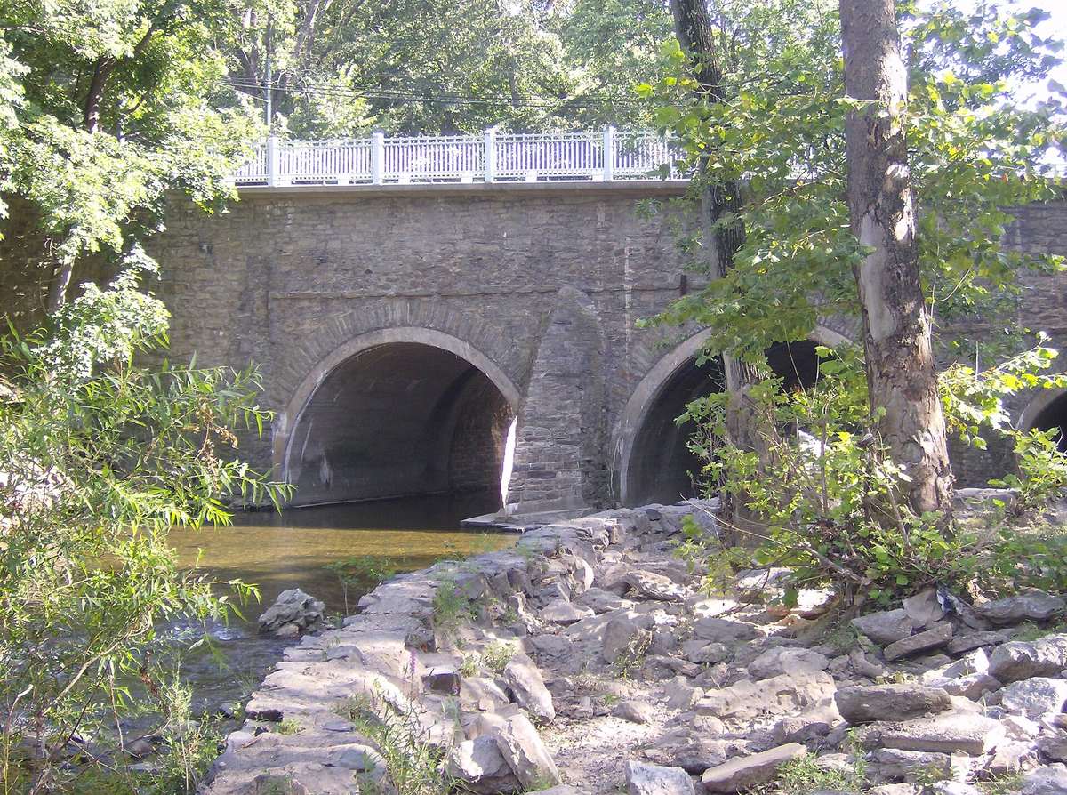
In 1697 a stone bridge was built across the creek, now called the Frankford Avenue Bridge. The American Society of Civil Engineers (ASCE) lists it as a historic civil engineering landmark and calls it the first known stone arch bridge built in the United States. It has three spans. According to ASCE, every adult man in the surrounding community had to give either labor or money to build it. It was first 18 feet wide, barely enough for two teams of horses to pass. It was widened in 1893 for trolleys and again in 1950 for cars, and it still carries Frankford Avenue (U.S. Route 13) over the creek. The National Park Service lists it in the National Register of Historic Places as the Frankford Avenue Bridge, "Frankford Ave. over Pennypack Creek", and the Fairmount Park archives on phila.gov call it one of the oldest stone bridges still in use in the United States.
The land became protected park space in 1905, according to the finding aid for the Pennypack Park maps and plans collection of the Fairmount Park Historic Resource Archives, published on phila.gov. That 2012 description gives a smaller area, roughly 1,400 acres, and lists Fox Chase Farm and the environmental center among the park's structures. Philadelphia Parks & Recreation says it protects more than 10,200 acres of public land and waterways across the city, and Pennypack is among its largest parks.
What to see in Pennypack Park
The creek trail. The Pennypack Trail follows Pennypack Creek. The city's site describes a paved bike path of about 7 miles and more than 60 miles of trails in the park. Visit Philadelphia says the paved and unpaved trails are used for hiking, biking, running and horseback riding.
The Frankford Avenue Bridge. The 1697 stone arches stand where Frankford Avenue crosses the creek; the Fairmount Park archives also call it the Holmesburg Bridge. ASCE notes that the creek is stocked with trout every year as far downstream as the bridge.
The environmental center. The Pennypack Environmental Center is at 8600A Verree Road, 19115. The city calls it one of three environmental education centers in Philadelphia's largest parks. Its page in the Parks & Rec Finder says it was dedicated as a bird sanctuary in 1958 and invites visitors to watch birds along the creek in the footsteps of John James Audubon and Alexander Wilson. Today it has an outdoor amphitheater, exhibits, a reference library, and campfire and picnic areas, on what was once the Verreeville mill site. Staff lead walks through the sanctuary and run programs for children and adults. Each year the center recruits volunteers for its Christmas Bird Count. The center's phone is (215) 685-0470.
The farm and old houses. Visit Philadelphia mentions several historic buildings in the park, a working farm among them, along with the Verree and Klein houses left from Verreeville. Other sights in the city are on the places to see in Philadelphia page.
How to get to Pennypack Park
SEPTA bus. The city says SEPTA bus route 67 runs along Verree Road through the park. SEPTA's stop list for the route includes stops on Verree Road from Oxford Avenue to Bustleton Avenue, among them Verree Rd & Rhawn St and Verree Rd & Bloomfield Av. Route 66 runs along Frankford Avenue, with a stop at Frankford Av & Pennypack St. Schedules and service alerts are on SEPTA's site.
By car. The city names trailheads at Verree Road, Krewstown Road, Benton Avenue and Winchester Avenue. The Pine Road picnic area has a parking lot next to a trail entrance.
Hours and admission
| What | What official pages say |
|---|---|
| Park admission | no fee listed on the city's pages |
| Curfew | Philadelphia Parks & Recreation's rules set a 10 p.m. curfew throughout the parks system |
| Trails | open dawn to dusk, seven days a week |
| Bikes and horses | no riding in the park between 10 p.m. and 6 a.m. |
| Soft-trail permit | required for bike and horse riders over 16; free for Philadelphia residents (a $20 donation is requested), $35 for non-residents |
| Environmental center, 8600A Verree Road | (215) 685-0470 |
| Park phone listed by Visit Philadelphia | (215) 934-PARK |
Hours and prices checked November 5, 2026 on phila.gov and visitphilly.com.
The city does not publish separate opening hours for Pennypack Park: its Parks & Rec Finder page shows only the status "Open regular schedule". The soft-trail permit is applied for online, as described on the city's Get a trail permit page.
Park rules
Philadelphia Parks & Recreation's rules and regulations say dogs and other pets must be on a leash no longer than 6 feet at all times. Alcohol is not allowed except at permitted events, and fires may be lit only in a stone fireplace or a metal barbecue stand.
Before you go: closed sections of the trail
Philadelphia Parks & Recreation posts trail alerts about closed sections on its phila.gov page. When a bridge or section is closed, the city suggests parking at another trailhead: Verree Road, Krewstown Road, Benton Avenue or Winchester Avenue. Check on the day you go, especially if you plan to bike the whole trail.
Questions people ask
Where is Pennypack Park in Philadelphia?
Pennypack Park is in Northeast Philadelphia along Pennypack Creek. Visit Philadelphia says it runs nine miles from Montgomery County to the Delaware River. Its listed address is 8500 Pine Road, Philadelphia, PA 19111, and the city names trailheads at Verree Road, Krewstown Road, Benton Avenue and Winchester Avenue.
How old is the Frankford Avenue Bridge?
It was built in 1697. The American Society of Civil Engineers calls it the first known stone arch bridge in the United States. It was widened in 1893 for trolleys and in 1950 for cars, and it still carries Frankford Avenue (U.S. Route 13) over Pennypack Creek. It is listed in the National Register of Historic Places.
Can I get to Pennypack Park by bus?
Yes. SEPTA bus route 67 runs along Verree Road through the park, and the Pennypack Environmental Center is at 8600A Verree Road. Route 66 runs along Frankford Avenue, the street the old stone bridge carries over the creek. SEPTA posts schedules on septa.org.
How many miles of trails does Pennypack Park have?
Philadelphia Parks & Recreation says the park has more than 60 miles of trails, and the paved bike path along the creek runs about 7 miles. Visit Philadelphia says people use the trails for hiking, running, biking and horseback riding.
Places on the map
Sources
- Pennypack Park, Parks & Rec Finder (City of Philadelphia)
- Philadelphia Parks & Recreation (City of Philadelphia)
- Pennypack Trail alert: trailheads and Pine Road parking (Philadelphia Parks & Recreation)
- Five hiking trails for fall fitness fun: Pennypack trail, Pine Road parking, SEPTA 67 (Philadelphia Parks & Recreation)
- Parks & Rec's environmental education centers, Pennypack Environmental Center (City of Philadelphia)
- Pennypack Environmental Center, 8600A Verree Road, Christmas Bird Count (City of Philadelphia)
- Pennypack Park Maps, Plans and Drawings Collection, finding aid (Fairmount Park Historic Resource Archives)
- Frankford Avenue Bridge, historic civil engineering landmark (American Society of Civil Engineers)
- Pennypack Park (Visit Philadelphia)
- Route 67 stops on Verree Road (SEPTA API)
- Route 66 stops on Frankford Avenue (SEPTA API)
- Pennypack Environmental Center, Parks & Rec Finder: 1958 bird sanctuary, phone (City of Philadelphia)
- Rules and regulations: 10 p.m. curfew, leash, alcohol, fires (Philadelphia Parks & Recreation)
- Trail regulations: trails open dawn to dusk, Pennypack soft-trail permits (Philadelphia Parks & Recreation)
- Get a trail permit: riders over 16, resident and non-resident fees (City of Philadelphia)
- Frankford Avenue Bridge, Frankford Ave. over Pennypack Creek, National Register of Historic Places (National Park Service)