RussiansInUSA editorial team · Facts checked November 5, 2026 · Official site
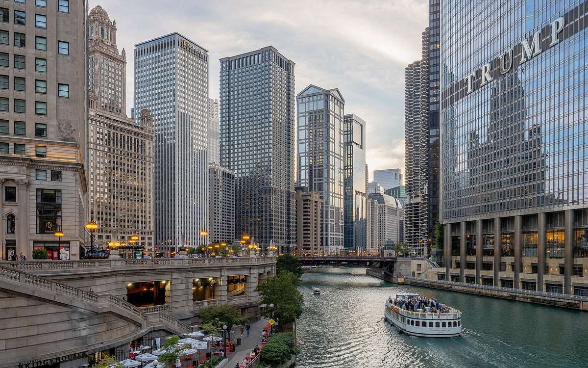
The Chicago Riverwalk runs along the south bank of the Main Branch of the Chicago River through downtown, from Lake Street to Lake Michigan at Lake Shore Drive. It is 1.25 miles long, free, and open daily from 6:00 am to 11:00 pm. People come to see the movable bridges and the skyscrapers from water level, to sit by the river, and to walk through a city history that is tied to this river at every step. The Chicago city page covers the city; this page is about the Riverwalk itself.
Chicago Riverwalk history, from Burnham to 2019
As the City of Chicago puts it on the Riverwalk site, Chicago exists because of the lake and the river. They were trade routes as early as the 1600s, and by the city's incorporation in 1837 the river was already a sought-after site for industry. The water was badly polluted, and for a long time a riverside promenade seemed impossible.
Architect and planner Daniel Burnham put a riverwalk in his 1909 Plan of Chicago, along with the Wacker Drive viaduct. The first piece came only in the 1970s: in 1972 the Illinois Central Railroad dedicated the strip between Lake Shore Drive and Michigan Avenue to the City as park. That is today's Esplanade, the eastern part of the Riverwalk.
West of Michigan Avenue, design began with the reconstruction of Wacker Drive in the 1990s. The build-out limits were agreed in a public process in 1999, with the US Coast Guard, the Army Corps of Engineers and other river users. The City had to formally set a new navigation channel: the Riverwalk may extend 20 feet into the river beneath each bridge, 25 feet between bridges and 50 feet between Franklin and Lake. Congress approved the build-out in 2004.
| Year | What happened |
|---|---|
| 2005 | Vietnam Veterans Memorial moved from Upper Wacker to between State and Wabash, dedicated on Veterans Day |
| 2009 | Under-bridge connections at Michigan and Wabash completed, the first phase |
| 2011 | In May, Sasaki Associates, Alfred Benesch & Co., Ross Barney Architects and Jacobs/Ryan Associates began designing the six blocks from State to Lake |
| 2015 | State to LaSalle opened in May |
| 2016 | LaSalle to Lake opened in the fall |
| 2019 | $12 million in Esplanade improvements: new path, lighting, seating, restrooms, about 150 trees |
The final segment was built with a $98.6 million federal TIFIA (Transportation Infrastructure Finance Innovation Act) loan. Concession revenue and tour boat fees are pledged to repay it over thirty years. The river level swings nearly seven vertical feet over a year, and some plantings are chosen to survive being submerged.
What to see on the Chicago Riverwalk
The bridges divide the Riverwalk into "rooms", and each block west of State Street has its own character:
- The Marina (State to Dearborn): seating, food and boat docking.
- The Cove (Dearborn to Clark): low to the water, for kayak access.
- The River Theater (Clark to LaSalle): a sculptural staircase from Upper Wacker down to the water, with trees and seating.
- The Water Plaza (LaSalle to Wells): a fountain where children can play with water.
- The Jetty (Wells to Franklin): piers and floating wetland gardens, with fishing.
- The Confluence (Franklin to Lake): an accessible walkway to Lake Street and a great lawn for watching the river.
The River Theater is the site of the Eastland disaster: on July 24, 1915, 844 people died when the Eastland capsized in the river.
From the Jetty you can watch Art on theMART for free. The Riverwalk site calls it the largest permanent digital art projection in the world, shown across the 2.5-acre river facade of theMART.
Public art lines the path. Gary Tillery's Vietnam Veterans Memorial carries the names of more than 2,900 Illinois service members killed or missing in action. Ellen Lanyon's Riverwalk Gateway, dedicated in 2000 beneath the Lake Shore Drive bridge, is a 127-foot covered walkway with 28 ceramic panels on the history of the city and its river. Carolyn Ottmers' ten-foot aluminum Allium stands between Columbus Drive and Lake Shore Drive. Kate Lynn Lewis's mural The Radiance of Being, celebrating 100 years of Art Deco architecture, is at the Community Marketplace just west of Michigan Avenue. The Esplanade also has a memorial to 28 submarines built in Wisconsin that went down the river to the Mississippi and on to the war.
At the southwest bridge tower at Michigan Avenue is the McCormick Bridgehouse & Chicago River Museum, 99 Chicago Riverwalk. At river level you see the huge gears of the movable bridge; from the top of the five-story building you get a 360-degree view. Chicago's First Lady cruises leave from 112 E. Wacker at Riverwalk level, and the Chicago Architecture Center is at 111 E. Wacker. The Riverwalk site counts 18 movable bridges in two miles of downtown river. More sights are on the Chicago places page.
How to get to the Riverwalk
Nearest stations, per the Riverwalk site and the Chicago Transit Authority (CTA):
| How | Get off at | Then |
|---|---|---|
| CTA Blue Line (Brown, Green, Orange, Pink and Purple also stop here) | Clark/Lake | walk two blocks north; ramp on the west side of Clark Street |
| CTA Red Line | Lake, on State Street | walk two blocks north; ramp on the east side of State Street |
| Commuter rail | Union Station or Ogilvie Transportation Center | walk to Lake Street, then east to the stairway down |
By car, take Upper Wacker Drive, not Lower Wacker. There is no official Riverwalk garage; many private garages are nearby. At the east end there is street parking on Lowest Wacker Drive between Lowest Michigan Avenue and Field Drive, and street parking on Wacker Drive is free on Sundays.
The CTA's Clark/Lake station page has arrivals and a trip planner.
Accessible ramps are west of Franklin Street, west of Clark Street, east of State Street and at Lower Stetson Avenue. There are no elevators yet; the City says they are planned.
Hours, prices and rules
| What | Hours | Price |
|---|---|---|
| Riverwalk | daily, 6:00 am to 11:00 pm | free |
| Art on theMART | viewed from the Jetty | free |
| Bridgehouse Museum | seasonal: spring to fall, closed in winter; Wednesday to Sunday 10 am to 5 pm in the 2026 season | pay what you can, suggested $5 to $10 |
Hours and prices checked November 5, 2026 on chicago.gov and bridgehousemuseum.org. On that day the museum was closed for the winter and its site said it reopens in spring 2027. The museum sets its season dates and hours each year, so check bridgehousemuseum.org before you go.
Rules from the official FAQ:
- Dogs are allowed on a leash.
- Bikes are allowed, but must be walked where signs say so.
- Your own food and non-alcoholic drinks are fine in designated areas, not in vendor areas.
- Alcohol only if bought and consumed at a vendor's location.
- No grilling.
The map, ramps and rules are on the official Chicago Riverwalk site.
Questions people ask
Is the Chicago Riverwalk free and what time does it close?
The Chicago Riverwalk is free to the public and open every day from 6:00 am to 11:00 pm, according to the City of Chicago's official Riverwalk site. You pay for food at the vendors and at the Bridgehouse Museum, which runs on pay what you can with a suggested donation of $5 to $10.
Can I bring a dog or ride a bike on the Riverwalk?
Yes. Dogs are allowed on a leash, and owners should follow any posted signs. Bicycles are allowed too, but in designated places they must be walked. The City asks visitors to use caution and mind the safety of others whether or not a sign is present.
Which CTA station is closest to the Chicago Riverwalk?
The Riverwalk site points to Clark/Lake on the Blue Line and Lake on the Red Line, on State Street. From either, walk two blocks north. From Union Station or Ogilvie Transportation Center, walk to Lake Street and take the stairway down to the Riverwalk.
Can you drink alcohol on the Chicago Riverwalk?
Only alcohol bought from a Riverwalk vendor and consumed at that vendor's location. Visitors may bring their own food and non-alcoholic drinks to designated areas, though not into vendor areas. Trash goes in the bins placed along the route, and grilling is not permitted anywhere on the Riverwalk.
Places on the map
Sources
- City of Chicago: Chicago Riverwalk
- City of Chicago: Chicago Riverwalk, Site History
- City of Chicago: Chicago Riverwalk, Frequently Asked Questions
- City of Chicago: Getting to the Chicago Riverwalk
- City of Chicago: Chicago Riverwalk, Learn
- City of Chicago: Public Art on the Chicago Riverwalk
- City of Chicago: Art on theMART
- Chicago Department of Transportation: Chicago Riverwalk
- CTA: Lake (Red Line) station
- CTA: Clark/Lake station
- McCormick Bridgehouse & Chicago River Museum: Plan a visit
- McCormick Bridgehouse & Chicago River Museum: About the museum
- McCormick Bridgehouse & Chicago River Museum